DUE TO CIRCUMSTANCES BEYOND OUR CONTROL THE VISION GROUP FOR SIDMOUTH IS NO LONGER ABLE TO PROVIDE CONTENT FOR THIS WEBSITE AND SO IT HAS BEEN ARCHIVED.
No new content has been added since April 2026.
If you would like to volunteer to provide content and help with the website please contact The Vision Group for Sidmouth
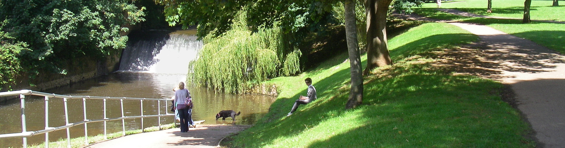
FLOODING IN THE SID VALLEY
Flooding issues are becoming more prominent across the country – and whilst the Sid Valley does not suffer to any great extent from flooding, there are nevertheless issues to be addressed.
AREAS PRONE TO FLOODING:
Parts of Sidmouth are in an official ‘flood warning area’:
… low lying properties and roads including, Primley Gardens, Mill Street, Riverside Road, York Street, Ham Lane, East Street and Fore Street areas.
River Sid at Sidmouth flood warning area – GOV.UK
Other areas are prone to flooding:
Flooded River Sid at the Ford Sidmouth Devon UK – YouTube
River Sid floods in The Byes Sidmouth 7th July 2012 – YouTube
Flooding at Sidford 24 November 2012
Devon villages ‘cut off’ after flooding – BBC News
FLOOD DEFENCES:
The Sid Valley has some very reliable flood defences along the River.
Much of the current flood defences were established by the predecessor of the Environment Agency after the severe flooding of 1968:
The ‘Great Flood Exhibition’ in Kennaway House on 7th & 8th July 2018 will commemorate the event. The Environment Agency have been invited and will be on hand to explain the works that have since been undertaken to help alleviate a recurrence of the events of July 1968.
Sidmouth’s Great Flood Exhibition
50th anniversary of the devastating floods in East Devon – GOV.UK
The flood gates at the ford on Mill Street are currently being updated:
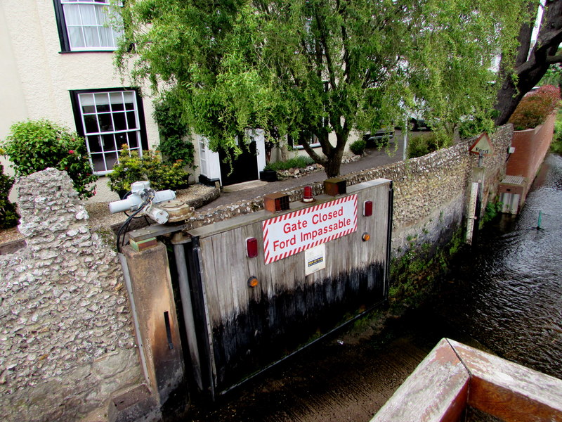
River Sid ford gate, Mill Street,… © Jaggery cc-by-sa/2.0 :: Geograph Britain and Ireland
There are also defences against flooding from the sea – with the announcement that funding has been found to improve them:
12 December 2023 – Funding confirmed for improved coastal defences in Sidmouth – East Devon
However, a constant theme running through years of the Beach Management Plan has been the protection of the Eastern cliffs – and thereby the Eastern Town:
Futures Forum: Pennington Point [2013]
Beach Management Plan: Saving Pennington Point – Vision Group for Sidmouth [2020]
CAUSES OF FLOODING: CLIMATE CHANGE:
The East Devon Catchment Flood Management Plan from the EA from 2012 points to the main concern over the coming years:
We are already managing the flood risk effectively, but we may need to take further actions to keep pace with climate change. Future increases in flood risk will mainly be driven by climate change. Land use management changes are likely to have less of an impact. Slightly more properties will be at risk, but the flood hazard remains generally low.
CAUSES OF FLOODING: DEVELOPMENT:
Following the 2012 floods, a report was put together – with the building of housing, an industrial estate and more hard infrastructure pointed to:
A DOSSIER on wet wild weather that bought the Sid Valley to a summer standstill has sparked a bid to better understand the risks posed by its river. Concerns over a proposed business park at Sidford and new housing in Woolbrook also feature in Devon County Council’s (DCC) Flood Investigation Report into the events of July 7.
Flood report reveals bid to better understand River Sid | Sidmouth Herald
Basically, the drains cannot cope:
Flooding in Sidmouth not caused by river or sea
These concerns were expressed at the time of the planning application for new housing in Woolbrook in 2014:
Meanwhile, ‘storm drain issues’ on Woolbrook Road have been getting worse:
Flooding issues in Sidmouth: part 2 – Vision Group for Sidmouth
As for the proposed industrial estate at Sidford as early as 2008, a report was warning about the impact of flooding:
Flooding is now more extensive and, according to the Halcrow Group report (2008), will be worse still by 2025 to the extent that even Flood Zone 2 will become Flood Zone 3a. Surface water flows down the hills, across the proposed access road and across the field like a river.
Sidford Business Park: flooding issues – Vision Group for Sidmouth
CAUSES OF FLOODING: POLLUTION AND RUN-OFF
There has been increasing awareness about the impact of inadequate management of ‘dirty water’ entering our rivers.
In particular, there has been a huge amount of media attention directed at the issue of pollution in our rivers and seas – with this summary from 2023:
Looking back over a year of assessing pollution in the Sid – The Sid
And an excellent overview from Ed Dolphin of the issues locally:
Sewage spill around Sidmouth’s beach: what’s it all about? – The Sid
Finally, the issues are very complex indeed:
A major issue is the build-up of river pollution – some of it from farmland. And whilst there are fears that this is making its way down to the beach, much of the run-off from agricultural land is emptying onto roads before it enters drains and the water system. The National Highways website reports on water run off from farmland – and here’s an example of a West Country road still flooded two weeks after storm Babet from last month.
How roads become rivers – Vision Group for Sidmouth
…